|
Reported Crop Circles for the State
of Washington -
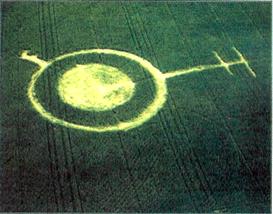
Kennewick, Benton County (May 28, 1993)
 A 60' diameter clockwise-swirled circle surrounded by an 17' diameter ring with a 'key'-type spur and a 72' long pathway with two 50' 'arms'. Described by the farmer as looking like a "one-eyed, hook-beaked creature standing on a pedestal" from the ground. W.C.Levengood confirmed that the formation plants exhibited statistical node bending differences (later to be known as the L-NEAT protocol); expulsion cavities were discovered. A 60' diameter clockwise-swirled circle surrounded by an 17' diameter ring with a 'key'-type spur and a 72' long pathway with two 50' 'arms'. Described by the farmer as looking like a "one-eyed, hook-beaked creature standing on a pedestal" from the ground. W.C.Levengood confirmed that the formation plants exhibited statistical node bending differences (later to be known as the L-NEAT protocol); expulsion cavities were discovered.
Crop
type: wheat
Source:
W.C. Levengood, ilyes
|
|
City
/ County / Date:
- Sacajawea
/ Pasco, Cowlitz County (1945)
- Moses
Lake, Grant County (August 21, 1964)
- Custer,
Whatcom County (January 1, 1965)
- Lynden,
Whatcom County (January 12, 1965)
- Harrah, Yakima County
(January 19, 1977)
- Centralia,
Lewis County
(April 1980)
- Kennewick,
Benton County
(May 28, 1993)
- Chehalis,
Lewis County
(July 8, 1994)
- Adna (1), Lewis County
(October 16, 1994)
- Adna
(2), Lewis County
(October 16, 1994)
- Chehalis,
Lewis County
(July 17, 1996)
- [Unknown]
(May 29, 1997)
- Coupeville
(1), Whidbey Island, Island County (May
26, 1998)
- Coupeville
(2), Whidbey Island, Island County (May
26, 1998)
- Eltopia
/ Pasco, Franklin County (June 19, 1998)
- Walla
Walla / Cottonwood Canyon, Walla Walla County (July 4, 1999)
- Burlington,
Skagit County
(September 8, 1999)
- Snohomish County (Fall, 2003)
- St.
John, Whitman County
(July, 2004)
- Wilbur,
Lincoln County
(June 27, 2007)
- Wilbur,
Lincoln County
(July 23, 2009)
|